I've driven by this trailhead a hundred times during the last 20 years, but have been scared off by tales of the trail's infamous 88 switchbacks, by its total lack of water and just by the fact that it has a dead-south exposure and is an extremely warm hike during the summer months.
But finally, the pure challenge of 4500' of vertical gain offering outstanding views at the top overcame my objections and I decided to give it a try. About 1.6 miles past the Salmon la Sac campground (and the end of paved road), take a left and head west down a rather rough road. As you approach the river, you'll find the upper parking lot, but continue another couple hundred yards to the trailhead, just south of which you'll find a rough area to park. The trail loses a hundred feet of elevation to an attractive bridge, where the trail proper starts. Shortly thereafter, the trail diverges--take the fork to the right and continue through sub-alpine forest for a couple miles, at which point the view opens up and the trail opens wanders through an area where a forest fire consumed the entire ridge a number of years ago. You can count switchbacks if you like, but trust me, there's a lot of up here and this trail is best-suited for the well-conditioned hiker with a lot of water.
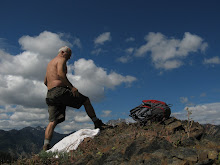
Between 4 and 6000 feet, enjoy more switchbacks and occasional valley views to the south, including Lake Cle Elum. Otherwise, there's nothing spectacular, just the thrill of working your quads and knowing you'll soon be entering into a lovely alpine environment. At 6000', the ridgetop is gained and the trail veers north and heads into a thin pine forest and toward the great traverse of Davis Peak. Near this divergence is a sidetrail with excellent rock scrambling, of which I heartily partook. While I didn't quite make it to the summit, I can easily imagine the views from the lookout to be stupendous. Those planning to go to the top and back should plan on at least 8-10 hours total hiking time and should probably bring a minimum of 3 quarts of water.
On a scale of 1-10, I'd rate this a 6.5. If you have the time and motivation to make it to the lookout which sits atop Davis Mountain, the hike could easily rate an 8 or 9, but it's a lot of elevation gain and kind of longish for a day-hike, especially when you throw in a roundtrip distance of almost 12 miles, IMHO. But getting above the tree-line is always good, the marmots were out and there is an excellent pool near the bridge at the end of the hike for a refreshing swim.