Sunday, July 19, 2009

Sasse Ridge


Up early to beat the heat, I left the house in Cle Elum at 7am. At about 730 I turned off the Salmon la Sac highway to Forest Service Road #128. The road is totally unmarked but is about 1 mile past the Thorp Lake turnoff and almost directly across from a small picnic area on the Cle Elum River. The road itself is a little rough, but not too bad until you get to around 3300', which is about 2.5 miles up from the highway. There is a nice place to park here at the end of a switchback. Vehicles with higher ground clearance can go further, perhaps cutting up to 4 miles off the hike (2 miles each way).

Follow the road roughly 2 miles and observe improving views to the west and south, including Mt Rainier. At 2 miles, the road splits--stay right, following the spur up another half mile to the road end. The somewhat obscure trail starts here, moving rapidly into cool forest. The trail is marked approximately 1/8 mile in as Little Salmon la Sac Trail.

Shortly the trails enters a steep area, bordering a large rock field on the right and forest on the left. In about one-quarter mile, the trail again trends north, back into the forest, leveling out nicely. In another quarter mile, water is found in the form of a small, swampy area. Using a convenient log, cross the swamp, picking up the trail again in the upper left quadrant of a wet, shady field. Here the trail continues up to the ridge line, which is reached in a few minutes.

To the south is Sasse Mountain, barely a quarter mile away as the crow flies. I went to the left, following the ridge north. The trail crosses steep fields of wildflowers and offers peakaboo views of Mt Stuart and more wide open views down the West Fork of the Teanaway River and further east toward Ellensburg and Blewett Pass.

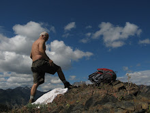
In another quarter mile, a high point of 5650' is reached with glorious views in all directions, particuarly to the west and south. Mt Rainier looms spectacuarly. Hiking distance from the car is about 4.25 miles, hiking time about 2.5 hours, back about 1.5 hours. With more time, the ridge could be followed further in both directions, resulting no doubt in a pleasant romp. Pack plenty of water, sunscreen and shades--it's hot and bright. Once the ridge is crossed, there is decent cell phone coverage.

Sunday, July 05, 2009

Paddy Go Easy Pass/Sprite Lake


Friday, July 3, 2009

Having spent much of last summer exploring many of the ridges and low mountains of the North Teanaway Valley, I decided this year to head a little west and check out some areas I hadn't been to in many, many years, if at all.

Up past the east side of Lake Cle Elum, the paved road ends at the popular Salmon la Sac campground, itself a jumping off point for many fine hikes. The road in a more primitive form continues north, past the rather quaint settlement of a score or so cabins in the Boulder Creek vicinity and eventually to Tucquala Lake, situated near the road end in an open, boggy valley, with 6000' ridges soaring to either side. It should be noted that just before the lake proper (near the Scatter Creek trailhead), the road crosses a rather deep creek. While the water depth had to be every bit of 18", most vehicles I observed, including my own Subaru Outback, had no problems. For low ground clearance cars, however, it's a serious obstacle--presumably more so during times of heavy snow melt.

The Paddy Go Easy trailhead is on your right, perhaps a half mile past the USFS field station. The trail was virtually unmarked during my visit, except for a sign that said "most difficult." The small parking lot is on two levels, with room for approximately 8 cars. Don't forget your parking pass! Elevation at the trailhead is about 3350 feet. Driving time from Cle Elum is about one hour. The last 11 miles of the road are gravel.

I started the hike at approximately 11am and the temperature was already in the mid-80s. The trail heads down a little bank to the right, crosses a small stream and meanders through some low brush until a couple hundred feet of elevation gain is achieved. At about one-half mile, the brush goes away and a more open, pine forest is presented with plenty of rocky soil for wildflowers, including wild roses and lupine. The trail continues up at a fair grade, occasionally switching back but more often just meandering in an ever-upward, fairly steep dimension. There are but half a dozen downward steps on the entire route.

Views down the Cle Elum River valley occasionally open up and the opposite ridge hides more views further south to Rainier and beyond until higher elevation is reached. At approximately 5500', the first snow and hence snow melt is encountered and on this hot day, it was a very welcome sight. Here the trail levels out a little and in another 3/4 mile or so, reaches the pass, with wide open views in virtually every direction. Crossing north over the ridgeline, snow is everywhere, making for a refreshing playfield of shallow, open slopes and tree-lined bowls. Hang a right, traversing an easy snowfield for about 1/4 mile and you come to Sprite Lake, nestled at the bottom of a long, steep slope and fringed with rocks and a few trees. At this time of year, the lake was just melting out on its edges. According to the map, if one continues another half mile to the east, just under the ridge, are a couple more lakes, much smaller but more isolated. Backpackers take notice--there are not an abundance of campsites near the lake, and of course, no fires are allowed.

On a scale of 1-10, I'd rate this hike a solid 8. Just the name of the pass is worth a couple points (being a good Irishman), the hike up was challenging but not absurd, the snowfields and views at the top were outstanding, and a classic, high-alpine lake was the clincher. Late in the summer, bring water as there likely won't be a drop on the trail until you reach Sprite Lake.