Sunday, November 30, 2008

Iron Mountain Trail


November 29, 2008


Again, things were quiet on the North Fork Teanaway road this drizzly, but warmish, Saturday morning in late November. The leaves now had all fallen from the aspens and cottonwoods and the larch had lost all their gold needles. With the gray skies and the flat light, there was little color to be found--perfect for keeping the dust and the crowds.

Trail 1394 starts about a mile before road end. Parking is on the south side of the road, the trail starts on the north. It starts up and it continues up, with nary five feet of flat until you get to about 5000. Views today were mostly of the fog, with some thin clouds swirling around the dramatic nearby Palisades and other massive granitic outcroppings, so common in this area.

The trail itself is fairly nondescript, winding it's way up a wide ridge in a thin pine forest. Spring and summer would be better, with a profusion of wildflowers, no doubt, spreading across the rocky forest floor. As previously mentioned, at 5000' the trail flattens a bit and views of the un-named pass and the top of the ridge open up. On a clear day, the view south and west would be rewarding. Today, through a pocket in the clouds, I settled for a weak rainbow, stretching across the creek bed, far below.

As the temperature was rising, snow was melting from the trail, exposing a solid sheet of ice below, much like a frozen stream. Just as I had slipped for the 16th time and was ready to turn around, a cold wind was felt blowing down from the pass, leaving the snow intact over the trail, making it easier to walk. At 6000' or so, the snow became quite deep and as it was now approaching mid-afternoon, I had a quick snack and started back. The pass itself, which I dearly wanted to see, was about a mile ahead and I'm sure, in clear weather, would have had spectacular views north to the Stuart Range.

After an easy and quick hike back down, I arrived at the car at about 330.

Monday, November 24, 2008

November 24, 2008


51-day reunion. Six months to go.

Oh boy--this is one of those days that you just dread, yet somehow look forward to. And not looking forward to getting it over with, but genuinely because you anticipate a positive result. This day brought out the best of those two opposing emotions, with the good clearly outweighing the bad.

After not seeing Tiana for 30 days, we were led to a small yurt on a hillside. There was a bright spot in the fog just overhead and the grounds of the school were beautifully quiet. We opened the door and sitting on the floor across the room was Tiana and her friend Marsha, who was also graduating from the program. Both kids were chatting excitedly and smiling as we walked in and Tiana immediately jumped up and gave Tuuli and I a big hug. Of course I immediately burst into tears (good self-control, Frank!) and the three of us just held each other for a long time, as our annoying dog was heard howling in the distance.

After a few brief formalities, the girls both went through their experiences of the last 30 days, what they had learned and what their goals were, going forward. Tiana went first and did so much better than our first meeting--I was quite pleased and very proud. Part of my prior dread was averted--Tiana did not make any kind of fuss about wanting to come home, and indeed, almost seemed to embrace the idea of another six months of boarding school. The dread that did materialize was my emotional response to her new-found maturity and self-confidence. I was just so, so happy to see the old Tiana, off all her medications and recreational drugs, physically fit and not consumed with her appearance. At one point she asked me if I liked her hair, as unkempt as it could possibly be. My response, with a wink, was "You know I do."

The rest of the afternoon was spent meeting new staff and getting Tiana and Marsha ready for their transition to the school part of the program. It all went very well, with Tiana in generally good spirits. At one point she told me she was going to work hard and get as many credits as she possibly could. She also told me, at least in so many words, not to worry--that she would be OK. That had a huge impact on me for one simple reason: empathy. One of Tiana's greatest failings, at least to me, was what I perceived a total and complete lack of understanding another person's point of view. Today was perhaps the first time ever that I saw she was able to understand my deeper feelings and relate to me on an emotional level. Perhaps it was just a random thought on her part, but for now I choose to believe it was the biggest sign of progress I have yet seen.

I also want to thank Savanna for making the trip. There were some emotional connection between the two girls that was good to see, including a hesitant hug that I had sort of dreamed of someday seeing.

The goodbye's were heartbreaking as Tiana was heading into a new, challenging realm that was very much an unknown for both of us. The long ride home gave rise to more introspection and a terrible emptiness that Tiana would not be home for the holidays, but contentment that everything is working toward a greater good, if we just give it time.

Sunday, November 23, 2008

Kendall (I Thought It Would be Steeper) Katwalk, Nov 22, 2008


I've been wanting to do this hike for years, but was always put off by stories about it's popularity and overuse. I don't mind encountering a few kindred spirits on any given trail, but due to it's proximity to Seattle and the appeal of the views and the Katwalk itself, I just couldn't get stoked about meeting as many as a couple hundred hikers on an typical summer/fall afternoon.

Finally, the timing was right as it was raining in the city, with cold rain and warm snow forecast for the mountains. As it turned out, we had just a little rain at the end of the hike, with occasional dry snow showers the rest of the time, and a bit of clearing thrown in here and there. Anyway, the strategy turned to perfection for as soon as we hit the Kendall Katwalk spur trail, we were breaking through virgin powder and didn't see another soul until we were merging onto the freeway.

The trail starts off with a couple mild, but fairly long switchbacks. With me were friends Adam and Jody, two avid hikers from Seattle who were braving the warmish beginning of the hike, at least, in just their long sleeve shirts. After 2.75 mostly uneventful miles, one can continue straight into the Commonwealth Basin, popular with snowshoers, or hang a right to the Kendall Katwalk. The trail becomes steeper and more interesting now, with occasional switchbacks through old growth forest and open views. On this day, the weather was highly unsettled with temps in the mid-to-upper twenties, light to fairly moderate snow falling and mostly overcast skies, with a bit of blue sky sometimes showing through.

Numerous creeks are crossed, some of which could be an issue during times of warmer temperatures and higher runoff. One creek in particular was very picturesque with a wide ribbon of water falling over a solid sheet of rock a couple hundred feet above (more about that later!). At 4700' the trail reaches a saddle and flattens briefly, offering views to the east and north to Kendall Peak. After a short while back in the trees, views open up and rock fields are traversed as the trail switches back up the west face of Kendall Peak. At this point we were postholing through 12-18" of dry snow and as we were now nearing 5000', the temps were dropping considerably. Finally Adam and Jody had their jackets on. It was snowing hard.

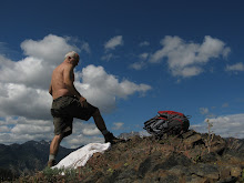
At 5400' and nearly 4.5 hours and 5.5 miles from the trailhead, we reached the Katwalk, a quarter mile section of trail blasted out of solid rock. The trail is amply wide with steep, but not sheer, dropoffs to the west. Views might have been spectacular on a clear day, but today about all we could see through the snow swirling up from the valley were a couple frozen ponds far below and the hazy outline of a steep ridge across the valley. We lunched at the north end of the Katwalk, where because my precious beef jerky was frozen and inedible, Adam insisted that I take his store-bought wrap. I declined his generous offer and moments later he was heard telling Jody that he thinks the wrap had gone back and asking her if it smelled funny. I found that quite amusing.

After a 20 minute lunch break, just long enough to bring on a serious chill, we headed back across the Katwalk, fingers freezing as I tried to take a few pictures. In fact, my fingers became so numb that I somehow lost the grip on the camera case I was holding and without realizing, totally dropped it. Even though it was probably just 30 or 40 yards back, I had absolutely no ambition to go back and look for it.

Back into the relative warmth of the deeper forest, Adam suggested we cut a long switchback, which the GPS showed should save nearly a mile of hiking. Seemed like a good idea and as we headed cross country things were going great until we came to the same impassable cliff over which the previously mentioned waterfall was flowing. As it was now getting fairly late in the day, we were reluctant to backtrack to the trail. Luckily, Adam was able to find a quite sketchy way down a very steep, but passable, section of the 200' face, hanging on to tree roots and bushes the entire way.

Finally we were on the trail and a couple hours later, in total darkness and with flashlights blazing, we were back to the parking lot, tired but exhilarated from a 7-hour walk in the mountains.

Logistics: Drive to Snoqualmie Pass on Interstate 90 (east) and get off at Exit 52. From the exit, turn left and cross under the freeway onto Alpental Road No. 54. In a short distance, follow a spur road on the right (should be signed PCT) a few hundred feet to the main parking lot, restroom and PCT trailhead, elevation 3,000 feet. If the trailhead is inaccessible due to snow, look for a wide, plowed pullout along the road, usually about 1/4 mile from the freeway. If there are no safe pullouts, you can park on the south side of the freeway and walk to the trailhead, or so they say.

Trail data: From the trailhead to the overlook it is 11 miles round trip with 2,700 feet gain, plus 300 feet gain on the way out From the trailhead to the crest of Kendall Ridge it is about a 1,700-foot gain. From the trailhead to Commonwealth Basin, it is about 6 miles round trip. Don't forget your parking pass and don't attempt the Katwalk in winter--there's way too much snow and the area is prime country for avalanches.

Friday, November 14, 2008

November 14, 2008


Another six months. I'm proud of you Tiana, and I love u.

:-(

Monday, November 03, 2008

Introspection Pass


November 2, 2008

One hour from Cle Elum, the North Fork Teanaway Road ended at the Esmerelda Basin parking lot. Wildly popular in summer as a jumping off point to the Alpine Lakes Wilderness Area, on this dark and rainy morning it was eerily quiet, as in absolutely no cars in the parking lot. That was just an exercise in curiosity on my part—my trailhead was actually a couple miles back at the equally desolate DeRoux Campground, Trail 1392, and my ultimate destination, an un-named, 1 mile off trail 1393A, about 4 hours away.

Starting elevation was 3200’, under mild, but drizzly skies. The trail begins flat in a thin pine forest, crosses DeRoux Creek and in a mile and half comes to a junction with trail 1392A. Here we hang a left, leaving the creek and start climbing—1200’ in less than a mile. Clouds were close at hand, rain falling harder, as the trail switchbacks up the ridge to Introspection Pass.

At the pass, a decision had to be made. Views to the south were obscured by scudding clouds and fog, and though I could clearly see the trail winding down the other side of the ridge, the view suddenly ended in a dark sea of green pines and firs. At this elevation, well over 5000', the weather was currently in a highly-changeable mood. On one side of the pass, the wind was coming up, blowing in snow from across the valley. Temperatures were dropping. The question was to go forward toward my dubious destination, into uncertain weather, or to retreat back to the north side of the ridge, in the lee of the wind and snow.

I sat on a convenient log to ponder my choices, as the snow and sleet mix continued from the southwest. It didn’t take long for me to make a decision. I was tired, beat-up and soaking wet from the long slog up the ridge. In the foggy, miserable weather, there was but little chance that I would ever find my destination, a tiny, one-acre, non-descript lake in the middle of nowhere. It was still another 2 hours down the trail, I would be losing my hard-fought elevation gain. all the while dealing with grumpy weather. It wasn’t worth the risk. The sensible thing was to regroup into familiar territory, where I was sure of my footing, and sure of the way back to safety.

The cold rain continued as I worked my way down the switchbacks, but as I got lower on the hill, it turned into almost a kind of warm mist. Just as I was getting into a zone and wishing the hike would continue, the trail came to a junction and I decided to take a spur to Gallagher Head Lake, 3.5 miles to the northwest. I had been to the lake once before from the Cle Elum River side, but that was probably 15 years ago. Two hours and 2500' of elevation gain later, I got a quick look at the lake and started back to the car. I arrived at the trailhead at approximately 2pm and was home by 3.