Sunday, August 31, 2008
Miller Peak, August 30, 2008 (Jammin' Pass Loop)
A couple weeks ago, I was up in this area, about two peaks over, and temps were in the low 90s, even at 6000+'. Today as I started out on the Miller Peak trailhead at around 1030 am, it was 40-50 degrees cooler. I'd been putting off this hike as the trail is open to and quite popular with, motorbikes. But I wanted to strike it from my list as it is the easternmost hike in the Teanaway realm and the last hike in the region that I hadn't completed.
Almost immediately I had second thoughts as a group of 10 riders passed me within 500' of the actual trailhead. But they were all respectful and friendly so I continued on. As it was, I only saw two more riders during the next 13+ miles.
As most trails in the Teanaway basin, the Miller Creek trail starts easy and flat but within a couple miles starts climbing up the ridge smartly, often through surprising patches of first and second growth forests. Various creeks and streamlets are crossed and as elevation is gained and trees thinned, views open up to the south and the north revealing Mt Rainier nearly covered in mist and the Stuart Range, peaking out above the Navaho Peak ridge. At 5000 feet you can relax a little and catch your breath and drink in the beauty of the high country. A light wind rustles through the dried arnica, their bright yellows flowers long since gone. A marmot whistles in the distance, hiding amongst the acres of bare rock. Various peaks and ridges, in virtually all directions, fill the camera frame and best of all is Miller Peak, looking not all that far away.
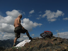
The last 1000' to the summit is straight up over loose rock, but once on top, one finds a little flat area with a few trees and plenty of cozy places to sit and soak in the scenery. Cell phone reception is possible here, so it's a great place from which to send a picture message to that friend who couldn't be with you.
Below the ridgeline to the south was an enticing side trail not indicated on the maps or GPS, which for that very reason had great appeal to me. Down I scrambled, nearly 1000 feet, and soon I was heading east on this seldom used trail, which I hoped would eventually hook me up with the Bear Creek trail, leading me back to the car in a nice, long loop. The trail was very pleasant, following just below the ridge with wide open views to the south and wast. I was a little concerned when the trail did not descend into the Bear Creek valley, but continued east. I kept expecting it to change direction, but it never did and pretty soon the trail just petered out, leaving me with very nasty scramble down a steep ridge to the very headwaters of Bear Creek, which I followed for nearly two miles, before picking up an old, un-maintained trai (probably the original Bear Creek Trail). Eventually that led to the main trail and by 6 pm I was back at the car, worn out after more than 7 hours of hiking.
I'm calling this "Jammin' Pass" Loop as I was listening to a Bob Marley tune when I passed a very clear defile in the ridge which seemed like a passage between north and south, a portal from my familiar stomping grounds of the Teanaway Valley through a hole in the ridge north to Chelan County and the unexplored regions of Ingalls Creek and the Stuart Range.
Monday, August 18, 2008
New Cat in the House
So they tell me we got a new cat. I know it's true because I've seen the scratching post, the kitty treats, the little cat abode, the cat toys, the litter box and the receipt from the spay and neuter clinic.
The cat has been in hiding since being brought home by Tuuli and Savi last Saturday when I was on my Earl Peak hike. The attached photo, taken by Tiana, looks suspiciously like our last cat, Kanga, but I'm assured it is a new, so far nameless, kitten. Kitten might be stretching it as I'm told she's almost a year old. Nonetheless, I'm convinced that we do have a new cat, so now if we can just do something with the dog, I might actually get a chance to see her.
Tiana's Driving!
Well, it's been almost a month since Tiana got her driver's permit and I'm happy to report no serious injuries have yet occurred. She's been doing great, the only exception being one time when we were practicing backing up, she got the brake and gas pedals mixed up and I had to slam on the emergency brake before we hit a neighbor's minivan.
We started our lessons at the Fisherman's Terminal complex on a quiet Sunday evening. We went over the basics and soon enough Tiana was at the wheel, navigating through the empty parking lots, the side streets and the adjoining Burlington Northern Railroad facility.
A few days later, she was on her first real street (Commodore Way) and a few days after that she negotiated her first real traffic and her first traffic light intersection. Pretty soon we were driving through Magnolia and Discovery Park. The only trouble Tiana was having was making tight turns, but she was doing fantastic in the light traffic that Magnolia had to offer. I asked her if she wanted to try driving home by herself and before I knew it we were going down Nickerson, past SPU, over the Fremont Bridge, through the heavier traffic of Fremont proper and up 8th Ave NW, all the way to the house. It was a great experience!
Next was another trip through Magnolia, then a run down to Baskin Robbins on busy Elliott Way. Again she managed the trip home just fine. Yesterday she drove cross town to Magnuson Park, up Sand Point Way a few miles, back down Sand Point Way past the village, through Montlake to Leschi and then up Madison, across Capital Hill/Broadway, over the University Bridge, through Fremont and back home, all without the slightest problem.
Soon we'll work on changing lanes, merging, backing up and parking. When she's comfortable with those skills, we're off to the freeway. So far I'm really proud of her and pleased how responsible and careful she has been. She's able to keep up with traffic, yet senses when it's appropriate to slow down. She doesn't follow too closely but knows enough not to allow too much space for other cars to cut in front of her. She just has a good feel for the road.
Photos to come!
Earl Peak, Aug 16, 2008
It started off hot, at the trailhead, through the tall trees standing shady beside Standup Creek in the Teanaway valley. It stayed hot, through the 3500' of elevation gain, as the trail switchbacked through thinning pines and rocky outcrops. It ended hot in the town of Cle Elum where we stopped for some burgers and were greeted with 95-degree temperatures, even at 6pm. Did I make the point? It was hot!
After picking up friends Jodi and Adam at Shilshole Bay Marina, we stopped by the boatyard and grabbed co-worker Adam V, who will be henceforth known as Adam V. We were on the freeway by 8, at the Cle Elum house/base camp around 930 and by 1030 we were hiking.
The trail starts off easy on an old logging road, skirting the west side of Startup Creek. After a couple miles and several creek crossings, the trail starts getting a little rocky and a little dusty, but mainly it starts getting a lot vertical. Fortunately, even as we were grinding our way up the south face of the 6000+ foot ridge, there were often respites of shade. If not the 85 degree temperatures would have killed us, or at least me.
Even more important to our little group than shade was the amazing abundance of water, which seemingly was never more than a few minutes away. Apparently, as we were to find out later, this area is filthy with springs, which formed year-round creeks as well as water that would just seep from the earth. On our way back down from the summit, we were hoping to reach the source of Startup Creek, which we could see just below the top of the ridge.
A few more grueling switchbacks and we were at the saddle where the Earl Peak hiker's trail starts. Views here were fantastic, north to the Stuart Range, including Mt Stuart and Mt Sherpa and south towards Mt Rainier, which was barely visible through the smog.
It was now almost 230 and after investigating the ridge that led to the Earl Peak, we decided to skip the summit and instead concentrate on the magnificent field of springs that were just below us. We were at 6500 feet and had enough up for the day. The springs were very intriguing, mainly because they were down (though just a little), they were wet and they presumably were cool and refreshing, which indeed they were found to be.
The field around the springs were rife with tall grass, wildflowers and dozens of cracks leaking water. One spring in particular was pouring straight out of the earth like a faucet and it's water was much cooler than some of the other springs. I filled my water bottles and drank straight from the spring until I had my fill. It was like nirvana (not the rock group), sipping the cool bubbling water as the sun beat down on the shadeless meadow.
After frolicking around for a while, it was time to get serious and descend the 3500' we had just gained. Losing patience, Adam V, methodically and much like a young mule, blazed the way down, reaching the car probably 45 minutes before the rest of us. We drove into Cle Elum, stopped at the Dairy Queen where I got perhaps the Absolute Worst Burger in the World. From there it was back to the house where we decompressed for an hour and half before heading back to Seattle, where we arrived at 930.
It was a hot, full day--very enjoyable thanks to the excellent company of the two Adams and Jodi. Since Jodi didn't get a spring named after her, I propose we call the meadow in which they were located "Jodi's Field."
Wednesday, August 13, 2008
Cruising 2008
It was an abbreviated cruise this year aboard my brother's 42' classic wood power boat. Savanna and I took sister Sue and brother in law Greg up to Anacortes Friday afternoon August 8, where we met brother Tim and sister in law Cathy at Skyline Marina, home of the world's longest fuel dock, at the very end of which Maraian II sat.
After a quick run to the local mini mart for Savi's provisions (mostly Cheetos and candy bars) and some cash, we were off to points west. A couple hours later we were through Mosquito Pass, sort of the unofficial entrance to the San Juans proper. After deliberating amongst the crew as to where to spend the night, we ended up anchoring at Stuart Island in a well-protected bay. It was a late night and by the time we had thawed out and eaten our lasagna, it was well after 9pm. Weather was calm but a little cloudy.
We were somewhat disappointed the next morning when the infamous bakery barge failed to appear with the much-anticipated cinnamon rolls, but we consoled ourselves with a pound of bacon and some fresh scones, which Susie and Greg prepared down below in the cozy galley. After more deliberation, we were off to points south which included better cell phone coverage, Friday Harbor and the start of the Shaw Island sailboat race, where we expected to meet up with several friends and co-workers.
The start of the race was the usual jumble of fast and slow boats, experienced and novice skippers and the occasional ferry boat cruising thru the congested start line. After exiting the harbor, some boats chose to go clockwise around Shaw Island on a spinnaker run, others chose to beat into the wind, going counter clockwise. The latter course was later found to be the best choice, as few of the boats going north even finished, due to calm winds and fluky currents.
Back in cruising mode, we headed north to Orcas Island where we spent a rainy, blustery afternoon and evening at the Deer Harbor Marina. Still was enjoyable as we had time to run the skiff over to Jones Island where we hiked around for a while and were able to stretch our legs in the vicinity of the marina, mostly be dodging local traffic. The marina also had a small store which served ice cream and french fries, the ultimate balanced diet for Savanna. We also enjoyed walking the docks, looking at all the different boats. I was telling Tim it was strange for me to be seeing the boats in their natural habitats, being so used to seeing them in the yard from the bottom up.
Next day we were up and cruising fairly early as Tim had to drop Kathy off in Anacortes so she could get back to work Monday morning. That accomplished, we continued into LaConner where we stayed at the dock Sunday evening, after having a great dinner at the local pizza brew pub. It was up very early the next day and by 630am we were well on our way back to Seattle. We all took turns with the steering, including Savi, and arrived at the locks in early afternoon, for a quick transit through to his marina. Tuuli picked us up at 2pm.
Monday, August 04, 2008
Centennial Trail Aug 2 2008
While we were momentarily flummoxed that the 17.5 mile trail we had planned on riding this morning ended after just a couple blocks into a non-descript service station parking lot, we soon enough realized the error of our way and were on the trail proper, heading out of Snohomish town to points north, and perhaps somewhat west.
Truly, the trail proper starts at a signed trailhead just outside of downtown Snohomish, goes for a couple blocks and abruptly ends. Thank goodness my sister Sue had the audacity to ask a postal employee where we could again pick up the trail and after a short detour we were there. One would think that this 6-block missing link might have been better described and/or signed, but such is the life of the intrepid bike trail explorer.
Northbound out of Snohomish, the trail is the typical rail conversion following valley bottoms, easy slopes and longish straightaways. We rolled along at an easy rate for the first ten miles or so, stopping for short photo opps next to slow moving streams, scenic overpasses and finally beside a quiet lake at about the 11 mile mark of the ride. At that point, the subdivisions gave way to more grazing and farming land, the sky was lowering with the threat of sprinkles and Sue had had enough riding for the day. Brother-in-law Greg and I seized the opportunity for a high speed run to the end of the trail and made the 14 mile round trip in about an hour.
Sitting on a bench overlooking the lake, the three of us snacked and rested for a few more minutes and soon on our way back to Snohomish, arriving a couple hours later. Wandering around the quaint riverside town we soon found a nice brew pub where we had a couple well-deserved beers and a nice lunch. An hour later we were back home, with plenty of the afternoon left to relax.
Subscribe to:
Posts (Atom)