Monday, October 05, 2009
Goat Lake
I try to get out just one time each summer on a little overnight trip, not only because I enjoy it tremendously and to keep in touch with my backpacking side, but to remind me of how difficult and challenging it can be. This trip was no exception: by the time I got to my destination I was already wishing I was back at the car, on my way home to enjoy a nice cold beer. My shoulders were aching, my thighs were burning and blisters were already forming on both heels.
The hike started out great, at about 930 in the morning, from the Cathedral Pass trailhead, at the very end of the Salmon la Sac road, just north of swampy Tucquala Lake. As a rare treat, Tuuli was with me for the first few miles, the first time we had been hiking together in years. The trail starts steeply up the dark side of Goat Ridge, switchbacking through a thick tangle of mossy firs and pines. At about 4500', most of the underbrush is gone, views open up and once the top of the ridge is reached, the sun came on like a furnace. The trail now continues north to Cathedral Rock and the nearby Squaw Lake, or you can hang a left and head south on the aptly named Trail Creek Trail, which ultimately leads to Waptus Lake and more specifically to the Goat Peak area, where I was headed. Here Tuuli and I parted company as it was getting late and I had to get trucking to reach my destination in time for dinner. She went to the lake and headed back home.
I had another 5 or 6 miles to go, the first couple of miles being very flat and scenic with the trail just sort of meandering through an open forest, occasionally crossing dried-up stream beds and for a very short while paralleling the quite pretty Trail Creek. Much of the area was strangely flat and open, but with few view opportunities--unusual for the high country. Of course it was very quiet with no signs of other hikers. The trail then began to lose elevation and finally at the bottom of a little gully was my turnoff, signed "Lake Michael."
The lost elevation was immediately regained, as the rough and rocky trail immediately began to climb the west flank of Goat Ridge. Nondescript at this point, the trail wound through open pine forests and blueberry bushes that had turned bright red. As the elevation approached 5000' the trail flattened out, which was a pleasant change for my worn out thighs and shoulders. The pack now felt like it weighed a hundred pounds and no matter how I adjusted the straps, I just couldn't get comfortable.
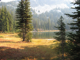
I began studying the GPS closely looking to find the best place to turn off the trail to get to my lake. The distance to the lake got down to about 1.3 miles and then started increasing, so I figured I wasn't going to get much closer. I found a little deer path and worked my way toward east and in about 1/2 hour crested a hill and looked down and saw water. It was about 5pm, the lake was bathed in a golden, late afternoon light and the acres of surrounding blueberry bushes appeared to be on fire. The unnamed lake was nestled into a little bowl with Goat Ridge to the east, Goat Peak to the south and a lovely beckoning meadow, just begging for a tent to be pitched.
After about an hour, the tent was pitched, just a few feet from the lake's edge and by 630 I was enjoying a lovely little freeze-dried Phad Thai, or Bhad Thai, as it will henceforth forever be known. A typical restless night ensued, with occasional glimpses of a black sky filled with thousands of light-filled holes. By midnight, the full moon had risen over the ridge, putting out the stars. I spent the rest of the night listening to the little FM radio on my cell phone and officially "got up" at 630am. I immediately brewed some of the Starbuck's Via instant coffee and spent the next couple hours sitting in front of the tent, waiting for critters to show up. In the end all I saw were a few birds and a couple chipmunks. Curiously, there was an area of flattened grass nearby that I had remembered from the night before. I have to assume some deer had slept there, but had done so so quietly that I never noticed.
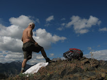
At around 9, I started up to the top of the ridge to get a closer look at Goat Peak, which I had hoped to climb. I found that my planned route was impassable due to a recent snowfall, so I spent a few minutes with the binoculars looking for goats, without any luck. I walked south on the wide open ridge for about a mile and then worked my way back to the lake. I packed up my things and by noon I was on the way back home.
Things I learned from this hike:
a) Fleece pants a fleece sleeping bag liner don't mix--they stick to each other like velcro, making it difficult to move around
b) Invest in a better pack. The one I used for this hike was a bargain basement special. Much better to spend a few extra bucks, get a pack that's lighter, has more pockets and fits better.
c) Same can be said for the tent. While nice and light and very spacious I had one zipper nearly break and I tore the nylon in one of the corner where the pole is seated.
d) Don't experiment with non-traditional dishes like phad thai. Better to stick to the freeze dried classic like beef stew and lasagna.
e) You can never have too many batteries for your camera and your GPS.
f) Bring sleeping pills next time.
Monday, September 14, 2009
N. Scatter Creek/Van Epps Pass
Well, this supposedly was at one point a sheep trail, for moving the critters into and out of the high country. It's basically a straight line from start to finish, with few concessions to human hikers. This trail made the Davis Peak hike a couple weeks ago look like a cakewalk and at the time, that had been this summer's standard for crazy-difficult hikes.
The Scatter Creek trailhead starts at 3200' about 1/8 mile off the main Tucquala Lake road, north of Lake Cle Elum, across from the Scatter Creek campground. The signed turnoff is just a bit past where the creek crosses the road (often dry in late summer). There's enough parking for maybe 4-5 cars. Heading north into the cool pine forest, the trail picks up Scatter Creek in about a quarter mile. It's here that that the trail start going up very smartly and it doesn't relent until a small meadow is reached at about 5800'.
The trail follows the creek for another one-half mile, bordering the top of an ever-heightening gorge, and then turns northward toward the spine of the ridge which it more or less follows for the next two miles. At about 5000' views open up to the west. On this day, at least, the sun now finds the trail and things can become very warm. After mid-summer there will be no water except for a very small stream near the pass, where I would recommend using a purifier, as it is a popular watering hole for various animals passing through.
At close to 6000' find the aforementioned stream and swamp and a couple flat spots for camping. Work your away across a wet meadow and pick up the faint trail on the other side. Go through a short section of forest at which point the trail enters a talus slope where you need to pay close attention not to lose your way. After climbing very steeply for a quarter mile, you enter another (drier) meadow, across which is Van Epps Pass, which appears as an opening between the trees. The pass itself is a classic example of a low point in a ridge separating two sides. The views on the other side are spectacular, across to Jack Ridge and beyond that to the Stuart Mountains. The trail now continues as the Meadow Creek Junction, down to the isolated Jack River Valley, far below. Around the pass are numerous campsites and unlimited rock scrambling opportunities.
The hike itself is only a little over 3 miles each way, but includes nearly 3000' of elevation gain. At 1000' gained per mile. the grade averages out to nearly twenty percent. Time up was 2.5 hours; time down was 1.5 hours. I rate this trail very highly as reaching the pass affords outstanding views and there is a great sense of accomplishment in completing such a strenuous hike. Make no mistake though--this is not for the faint of heart. You must be in decent physical shape or this trail will play you out after the first half mile.
Monday, August 31, 2009
Davis Mountain
I've driven by this trailhead a hundred times during the last 20 years, but have been scared off by tales of the trail's infamous 88 switchbacks, by its total lack of water and just by the fact that it has a dead-south exposure and is an extremely warm hike during the summer months.
But finally, the pure challenge of 4500' of vertical gain offering outstanding views at the top overcame my objections and I decided to give it a try. About 1.6 miles past the Salmon la Sac campground (and the end of paved road), take a left and head west down a rather rough road. As you approach the river, you'll find the upper parking lot, but continue another couple hundred yards to the trailhead, just south of which you'll find a rough area to park. The trail loses a hundred feet of elevation to an attractive bridge, where the trail proper starts. Shortly thereafter, the trail diverges--take the fork to the right and continue through sub-alpine forest for a couple miles, at which point the view opens up and the trail opens wanders through an area where a forest fire consumed the entire ridge a number of years ago. You can count switchbacks if you like, but trust me, there's a lot of up here and this trail is best-suited for the well-conditioned hiker with a lot of water.
Between 4 and 6000 feet, enjoy more switchbacks and occasional valley views to the south, including Lake Cle Elum. Otherwise, there's nothing spectacular, just the thrill of working your quads and knowing you'll soon be entering into a lovely alpine environment. At 6000', the ridgetop is gained and the trail veers north and heads into a thin pine forest and toward the great traverse of Davis Peak. Near this divergence is a sidetrail with excellent rock scrambling, of which I heartily partook. While I didn't quite make it to the summit, I can easily imagine the views from the lookout to be stupendous. Those planning to go to the top and back should plan on at least 8-10 hours total hiking time and should probably bring a minimum of 3 quarts of water.
On a scale of 1-10, I'd rate this a 6.5. If you have the time and motivation to make it to the lookout which sits atop Davis Mountain, the hike could easily rate an 8 or 9, but it's a lot of elevation gain and kind of longish for a day-hike, especially when you throw in a roundtrip distance of almost 12 miles, IMHO. But getting above the tree-line is always good, the marmots were out and there is an excellent pool near the bridge at the end of the hike for a refreshing swim.
Saturday, August 08, 2009
Huckleberry Mountain
Didn't See A Single Huckleberry
Any hike with "Mountain" in it has sounded very appealing to me the last couple summers. When you add in "Huckleberry" and late summer, well, it's almost too much to pass up.
So the timing being right, and the name being right, and I was on my way to Huckleberry Mountain, a modest sort of mountain at a little under 5700', but just perfect for this coolish Saturday morning.
To get there, head out past Lake Cle Elum and at Salmon La Sac, where the paved road ends, veer right and head north for approximately 5.1 miles, turning right onto an unmarked side road. At less than .5 mile, find the a place to park just before the sign that says 4WD and just pass the turnoff to the Boulder-DeRoux trailhead.
I started the hike up the old jeep road (totally impassable for passenger vehicles), and immediately went past an old log cabin, well-maintained but vacant. Here the switchbacks began in earnest, looking like a snake on the map, as the rugged road works its way up the north side of Huckleberry Mountain, mostly through shady forest, with only occasional views southward down the Cle Elum River valley. The elevation gain is steady, if not spectacular and one wonders how even a super-Jeep could possibly get through, but fresh tire tracks show they they can.
At 3 miles is a wonderful spring with a mini-waterfall right next to the road. You can fill up your canteen here--this is the only water on this hike. In another quarter mile, the road forks with the main leg heading rightish, and the left switchback continuing up the mountain. Another half mile and the road ends and there's just a steep scramble to the top, not more than a quarter-mile. Work your way to the west and north side of the summit for smashing views. Hiking time to the top is about 2.5 hours, hiking time back down about 1.5 hours. Elevation gain 2300+ feet.
This is a nice hike, with the spring and the views being the primary payoff. Judging from the tire tracks, one may expect to encounter off-road vehicles. the threat of which leaves one somewhat disconcerted. This day however, I say neither man nor machine. Unfortunately, I also didn't see the mountain's namesake, which was a great disappointment.
Sunday, July 19, 2009
Sasse Ridge
Up early to beat the heat, I left the house in Cle Elum at 7am. At about 730 I turned off the Salmon la Sac highway to Forest Service Road #128. The road is totally unmarked but is about 1 mile past the Thorp Lake turnoff and almost directly across from a small picnic area on the Cle Elum River. The road itself is a little rough, but not too bad until you get to around 3300', which is about 2.5 miles up from the highway. There is a nice place to park here at the end of a switchback. Vehicles with higher ground clearance can go further, perhaps cutting up to 4 miles off the hike (2 miles each way).
Follow the road roughly 2 miles and observe improving views to the west and south, including Mt Rainier. At 2 miles, the road splits--stay right, following the spur up another half mile to the road end. The somewhat obscure trail starts here, moving rapidly into cool forest. The trail is marked approximately 1/8 mile in as Little Salmon la Sac Trail.
Shortly the trails enters a steep area, bordering a large rock field on the right and forest on the left. In about one-quarter mile, the trail again trends north, back into the forest, leveling out nicely. In another quarter mile, water is found in the form of a small, swampy area. Using a convenient log, cross the swamp, picking up the trail again in the upper left quadrant of a wet, shady field. Here the trail continues up to the ridge line, which is reached in a few minutes.
To the south is Sasse Mountain, barely a quarter mile away as the crow flies. I went to the left, following the ridge north. The trail crosses steep fields of wildflowers and offers peakaboo views of Mt Stuart and more wide open views down the West Fork of the Teanaway River and further east toward Ellensburg and Blewett Pass.
In another quarter mile, a high point of 5650' is reached with glorious views in all directions, particuarly to the west and south. Mt Rainier looms spectacuarly. Hiking distance from the car is about 4.25 miles, hiking time about 2.5 hours, back about 1.5 hours. With more time, the ridge could be followed further in both directions, resulting no doubt in a pleasant romp. Pack plenty of water, sunscreen and shades--it's hot and bright. Once the ridge is crossed, there is decent cell phone coverage.
Sunday, July 05, 2009
Paddy Go Easy Pass/Sprite Lake
Friday, July 3, 2009
Having spent much of last summer exploring many of the ridges and low mountains of the North Teanaway Valley, I decided this year to head a little west and check out some areas I hadn't been to in many, many years, if at all.
Up past the east side of Lake Cle Elum, the paved road ends at the popular Salmon la Sac campground, itself a jumping off point for many fine hikes. The road in a more primitive form continues north, past the rather quaint settlement of a score or so cabins in the Boulder Creek vicinity and eventually to Tucquala Lake, situated near the road end in an open, boggy valley, with 6000' ridges soaring to either side. It should be noted that just before the lake proper (near the Scatter Creek trailhead), the road crosses a rather deep creek. While the water depth had to be every bit of 18", most vehicles I observed, including my own Subaru Outback, had no problems. For low ground clearance cars, however, it's a serious obstacle--presumably more so during times of heavy snow melt.
The Paddy Go Easy trailhead is on your right, perhaps a half mile past the USFS field station. The trail was virtually unmarked during my visit, except for a sign that said "most difficult." The small parking lot is on two levels, with room for approximately 8 cars. Don't forget your parking pass! Elevation at the trailhead is about 3350 feet. Driving time from Cle Elum is about one hour. The last 11 miles of the road are gravel.
I started the hike at approximately 11am and the temperature was already in the mid-80s. The trail heads down a little bank to the right, crosses a small stream and meanders through some low brush until a couple hundred feet of elevation gain is achieved. At about one-half mile, the brush goes away and a more open, pine forest is presented with plenty of rocky soil for wildflowers, including wild roses and lupine. The trail continues up at a fair grade, occasionally switching back but more often just meandering in an ever-upward, fairly steep dimension. There are but half a dozen downward steps on the entire route.
Views down the Cle Elum River valley occasionally open up and the opposite ridge hides more views further south to Rainier and beyond until higher elevation is reached. At approximately 5500', the first snow and hence snow melt is encountered and on this hot day, it was a very welcome sight. Here the trail levels out a little and in another 3/4 mile or so, reaches the pass, with wide open views in virtually every direction. Crossing north over the ridgeline, snow is everywhere, making for a refreshing playfield of shallow, open slopes and tree-lined bowls. Hang a right, traversing an easy snowfield for about 1/4 mile and you come to Sprite Lake, nestled at the bottom of a long, steep slope and fringed with rocks and a few trees. At this time of year, the lake was just melting out on its edges. According to the map, if one continues another half mile to the east, just under the ridge, are a couple more lakes, much smaller but more isolated. Backpackers take notice--there are not an abundance of campsites near the lake, and of course, no fires are allowed.
On a scale of 1-10, I'd rate this hike a solid 8. Just the name of the pass is worth a couple points (being a good Irishman), the hike up was challenging but not absurd, the snowfields and views at the top were outstanding, and a classic, high-alpine lake was the clincher. Late in the summer, bring water as there likely won't be a drop on the trail until you reach Sprite Lake.
Sunday, May 24, 2009
Tiana's Home
On October 6, 2008 I had a header in my blog titled, "Tiana's Gone." Now I am so happy to write that Tiana's back home again, nearly 8 months later. Tonight she will sleep in her own bed, use a flushing toilet and be able to wash up using warm water. She will be able wear a watch again and nobody will collect her shoes before bedtime. In losing so much structure, she will be gaining freedom and independence and the ability to make choices. All of us are optimistic.
Yesterday was mostly about a long, hot drive through Eastern Oregon and Washington. We left Bend at about 11, headed north on 97 and rolled into Cle Elum at a little before 6pm. We got Tiana some good driving time, and she did well and has probably already forgotten about the accident on Saturday. We had dinner at El Caporal and played cards until about 10. We all went to bed early.
This morning Tiana was up by 830 and Savi shortly thereafter. A quick breakfast and we were out the door, with Tiana getting her first real freeway driving ever. Traffic was heavy until almost Easton, then broke up and was fine the rest of the way. We rolled onto 73rd and I must admit I got a little teary eyed as our good old house came into view, as did Tiana. She was very excited as we stopped the car and she saw the sign I had put on the front porch.
We'll all sleep better tonight....
Subscribe to:
Posts (Atom)